Elgin Deanery
Bellie
"Beul-aith"
Parish Church: OS Ref: NGR NJ 353610 H.E.S. No: NJ36SE 5 Dedication: St Ninian or St Peter or St Mary
Associated Chapels: Bog o' Gight {NGR NJ 350595}; Braes of Enzie {NGR NJ 391590}; Fochabers Bede-House {NGR NJ };
It is very possible that there was a church here, at Bellie, from very early times - before Fochabers was a town of any substance and certainly before the vast presence of the Bog o' Gight cast its shadow over the countryside. But why should there be a church here at all?
It is commonly accepted that the ancient tribes-people of this part of Scotland were, like many others from different areas across Europe, very superstitious. One of their beliefs was that water was the home of spirits and supernatural forces and so a river of the magnitude of the Spey presented a formidable obstacle to the traveller, not just of a physical nature but also one which had a supernatural dimension. Very few people could swim at all in those days and certainly none would have had the ability to put their strength to the test against the overpowering forces of a river such as the Spey! But cross it they did, either by using a 'ford', where the water was shallower, or by boat. But such a crossing presented a supreme challenge and required all the help that it was possible to engage.
Throughout Scotland, and certainly here in the north-east, chapels and churches are to be found in what seem to to us today to be the most unlikely of places, until one understands that they marked either the beginning or the end of a crossing. This could be either at the end of a mountain 'road' or the place of passage over a river. At both places the traveler would want to pray, either for a safe crossing, or to give thanks for having made a safe passage.
Bellie was one such place since, from time immemorial, there has been a crossing point over the river here - at what became known as Boat o' Gight. King Edward I crossed the Spey here, with his vast army, on his way to Elgin. The Marquis of Montrose also crossed here, but in much later times. Indeed, this was one of the most popular crossing points on the Spey and this fact is remembered in the name of the lands of Gordon Castle which approach the river-bank here. The area called Ferry Bank lies between the main entrance to the Castle from the Inverness to Aberdeen road and the river. Cumberland's Ford is also marked on older maps directly west of Bellie Church. The section of the river between Fochabers Bridge and Cumberland's Ford is known as the Currach Water, reflecting the name of the ancient craft that would have been used to ferry travellers.
"The history of Bellie reaches back to very remote times. About 1150-1153, King David I gave a grant of the territory which included Fochoper {Fochabers} on the east of the Spey, and Finfans on the west, along with a right of fishing on the Spey and the patronage of the church of Bellie," to his newly founded Abbey at Dunfermline.3 These lands were then passed to Urquhard Priory at its foundation as a daughter priory of Dunfermline. This seems to confirm that Bellie was a pendicle of Urquhard, since Fochober was also given to the Priory in 1147-1153. This, of course, also resulted in the Prior of Urquhart gaining the patronage of the church of Bellie - and a very valuable fishing!


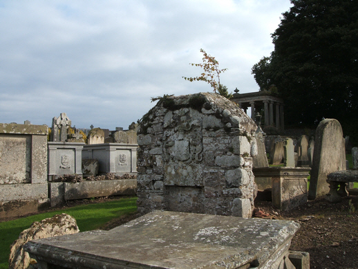
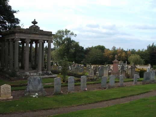
Above: Views of the graveyard at Bellie.
When Urquhard Priory and Pluscarden Priory were united in 1454, this church, both parsonage and vicarage, became the property of the new Benedictine Priory of Pluscarden.
MacFarlane suggests that this Church was dedicated to St Mary and was, at first, a chapel-of-ease dependent upon Urquhard Priory. He suggests that after the Second Reformation (1560) the church was expanded because of the proximity of the family estate of the Gordon Earls of Huntly.1 For many generations, this family was staunchly Catholic. In pre-Reformation days this chapel, and that at the Braes of Enzie, were served per vices., by a single priest. The story is told that one of the priests died en-route between these two chapels and the place where his body was found was revered by the local populace for many years. Crammond, however, states that this church was dedicated to St Peter.2
This parish originally straddled the Spey: the dabhach of Lannens (now Lunan) was on the west bank of the river.7
No memorial survives within the churchyard of Bellie to commemorate the memory of John, Lord Graham, the eldest son of the Marquis of Montrose, who, "...was a proper youth almost sixteen years old and of singular expectation, takis seiknes, deis in the Bog in a few days, and is buriet in the Kirk of Bellie to his fatheris gryt greif." His father and he had left Elgin on 4 March, 1645, on their way to Bog o Gight.
Fairs were held at Bellie on "the five Feast Days of St Mary" - Candlemas (2 Feb); Lady Day in Lent(ron) (25 March); Marymas (15 Aug); Lady Day in Harvest (8 Sept); Latter Lady Day (8 Dec). The old fairs or markets of SS Catherine and Mungo, and the Holyrood Fair, were long held in the neighbourhood of Fochabers and seem to indicate that there may have been altarages, or even chapels, with these dedications in the vicinity.
There was a Well of St John near Aulthash
There is a Roman Camp close to this church - somewhat to the north-east, about 150m away.
Bog o' Gight: (Gael. Bog na gaoith - "the windy bog") On 16 January 1362, John Hay of Tullyboyle {Tullybody in Clackmannanshire} had a charter from King David II, signed in Aberdeen, of the whole lands from the Spey to the burn of Tynet, which are described as lying within the royal forest of Awne or Enzie, and to reduce them into cultivation.4 His predecessor, Gilbert de Hay, first obtained a charter of these lands from King Robert I.
About twelve years later, the same baron, with consent of his son John, founded a chapel at le Geth (Gycht) in honour of of the B.V.M. and All Saints, for the sake of his own soul, those of his predecessors and successors and all the faithful departed, "hac mea fundatione ecclesie matrici prejudicante nullatenus quove modo". This was endowed with an annuity of £4 per annum of the rents of Awyn (half at Pentecost & half at Martinmas) with a house for the chaplain, also four acres of land at Ladardach, and pasturage there for 12 cows and a bull, 60 sheep and lambs, two horses, one of which was to have pasture in the same field with the lord's own stud, etc.; while the jurisdiction of the foundation was given to the Bishop and Chapter of Moray.5 This place of worship appears to have been situated somewhere about [Old] Gordon Castle.
Braes of Enzie (St Ninian): This, like Bellie, is supposed to have originally been a chapel-of-ease belonging to Urquhard Priory. As its dedication implies, this is supposed to be one of the oldest Christian foundations in the country. Roman Catholic priests of the Diocese of Aberdeen are still buried here. The place-name Chapelford, in the dabhach of Ordargaties, is called St Ringan's in an early map.8
Fochabers - Bede House: "In Fochabers there is a large sclated house in the lower story of which are maintained several popish beadmen wearing their bleu gowns; the upper story furnished with altar, etc., for popish mass".6 It would seem that this bede-house was founded by the Gordon family.
Clergy:
(no pre-Reformation clergy are known to-date.)
1. MacFarlane, W. (1906-8) Geographical Collections Relating to Scotland. Edinburgh: Scottish History Society. Vol. 1., p.240.
2. Crammond, Wm. (undated) The Church and Parish of Bellie. Elgin: Courant & Courier. p.3
3. ibid. p.23
4. Registrum Magni Sigilli Regnum Scotorum, p.24
5. Moray Reg., no.246, p.321.
6. MacFarlane (1906-8), p.241
7. Ross, A.D. Unpublished PhD Thesis submitted to Aberdeen University 2006. vol.i., p.55
8. ibid., vol. i., p.56; Ordiga Acres, an area of rough pasture, is marked on the OS Six-inch Survey of 1872, Banffshire, Sheet VII, at a position that approximates to [NGR NJ 372603]; Robert & James Gordon's Map (1632-1650) of Strathbogie and Aenzie shows St Ringan's to the east of Ordidazach. {https://maps.nls.uk/view/00000358}; Blaeu's Atlas (1654) shows St Ninians very clearly. {https://maps.nls.uk/view/00000453}
e-mail: admin@cushnieent.com
© 2019 Cushnie Enterprises
